by
, , , , , , and


Geographies 2023, 3(3), 574-583; https://doi.org/10.3390/geographies3030030 (registering DOI) - 01 Sep 2023
Abstract
►
Show Figures
Foraminifera are widely used in paleoclimatic and paleoceanographic studies, providing information about past ocean conditions. However, in order to use these tracers, it is essential to obtain an accurate chronology. Radiocarbon has proven to be a powerful tool in developing robust chronologies. Sample
[...] Read more.
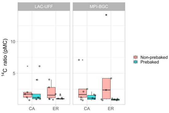
Foraminifera are widely used in paleoclimatic and paleoceanographic studies, providing information about past ocean conditions. However, in order to use these tracers, it is essential to obtain an accurate chronology. Radiocarbon has proven to be a powerful tool in developing robust chronologies. Sample sizes of a few milligrams of carbonate material are needed for precise radiocarbon determination using accelerator mass spectrometry (AMS). In the specific case of paleoceanographic and paleoenvironmental studies, Foraminifera microfossils are the most important indicator of oceanic conditions. However, for establishing the chronology of deposition, sample availability is often limited. In AMS facilities using solid ion sources, such as the Radiocarbon Laboratory of the Universidade Federal Fluminense (LAC-UFF), in Brazil, CO2 samples need to be converted to graphite after physical and chemical pre-treatment to remove contamination. Reducing the sample sizes increases the relative contribution of contamination and can favor increased background levels. In this work, we tested different amounts of 14C-free carbonate samples as a means to evaluate the pattern of contamination. For the sealed tube Zn/TiH2 graphitization method, we tested prebaking the graphitization tubes and compared storage procedures. As a result, the background for regular-sized samples was decreased, and accurate measurement of carbonate samples containing ca. 0.5 mg C could be performed. Prebaked graphitization tubes can safely be stored in desiccator cabinets for up to 4 weeks. Foraminifera samples with mass as low as 1 mg (ca. 0.1 mg C) can now be measured at the LAC-UFF AMS facility, provided that C contamination can be estimated and corrected. The developments presented in this work allowed for the study of species-specific Foraminifera and other small-sized carbonate samples.
Full article

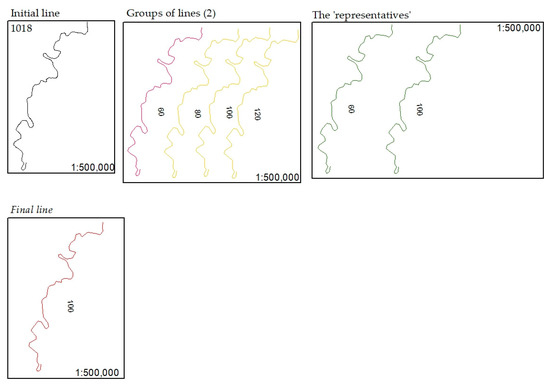
Figure 1


